


This is the authors' second book on the Brecon & Merthyr Railway and describes the section from Bargoed to Pontsticill Junction and the short branch line from Pant to Dowlais Central.
It contains photographs of every location along the line, including many that have not been published before, and a fascinating account of the Pant-y-Waun Marshalling Yard that was operative until Dowlais Ironworks ceased production.
Published in October 2022 as part of Pen & Sword's “South Wales Valleys” series, this hardback book written by John Hodge & Ray Caston measures around 21.59 cm x 27.94 cm, has 120 pages, 220 black and white illustrations, and 11 maps. It has a published price of £25.00, and at the time of writing Pen & Sword has it available online for £22.50 and it can be obtained from Amazon for £20.
On reading this book it becomes clear that it lacks any background information on why and when the Brecon and Merthyr Railway was built or its history until its closure.
I assume that all such information is contained in Volume 1, and anyone who wishes to know more about the railway other than just information about the locations covered in this book will therefore need to purchase the previous volume.
The book has three chapters, with Chapter 1 describing services after the Grouping based on the 1924 timetable, Chapter 2 describes each location between Bargoed and Pontsticill Junction, and Chapter 3 describes each location from Pant to Dowlais Central as well as passenger & freight workings on that section of the line and a history of Dowlais Iron Works.
Although the title of Chapter 1 appears to show that it covers timetabled services in 1924, it also includes lists of services running over 30 years later, in 1958 and 1959.
As Chapter 2 describes the stations on what could be termed the railway's main line between Bargoed and Pontsticill Junction, other than the brief details included in Chapter 1 the book does not include the same level of detail for services on that section of line as that provided for the short section between Pant and Dowlais Central in Chapter 3.
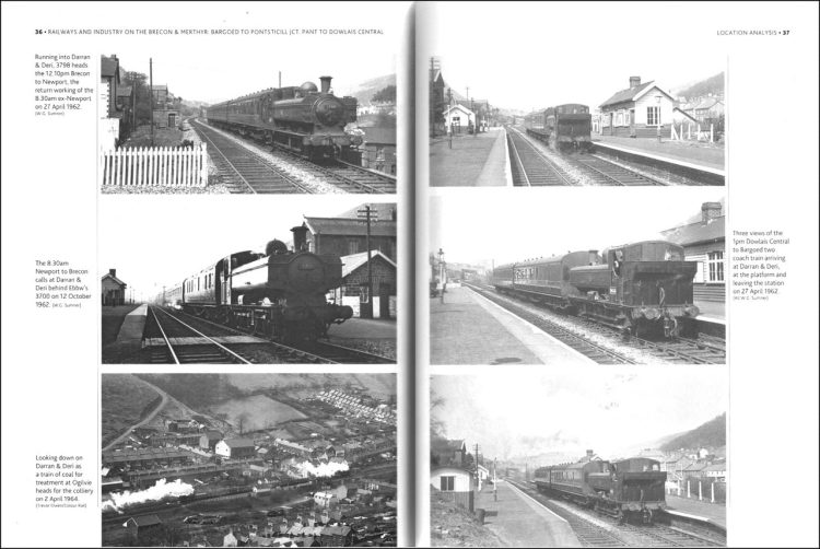
There are a number of instances in the book of several photographs showing the same subject, such as the ones on the right below that show three views of the same train arriving at the oddly-named Darran & Deri station.

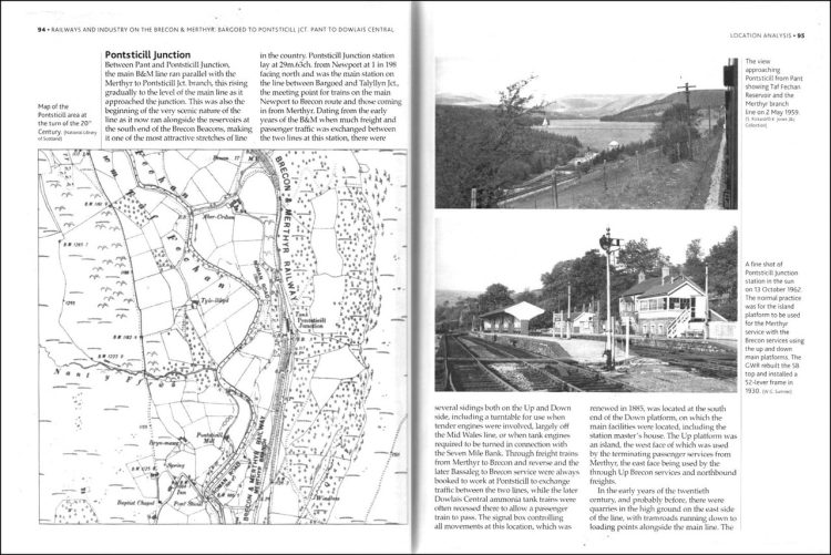
Large-scale Ordnance Survey maps are a useful addition for some locations where the railway layout was quite complex. One such map is on the left below showing the Brecon & Merthyr and London & Northwestern Railway lines around Dowlais Top and Pant-y-Scallog.
The photos on the right, especially the centre and bottom ones, show just how bleak the landscape was on this part of the line.

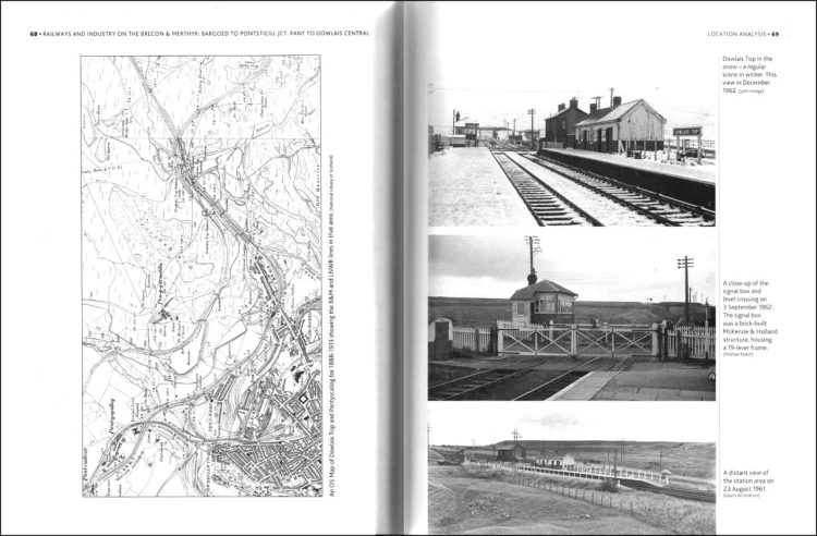
Snow features in various photos throughout the book, such as the middle one on the right below, emphasising the difficulties there must have been in operating the line in winter.
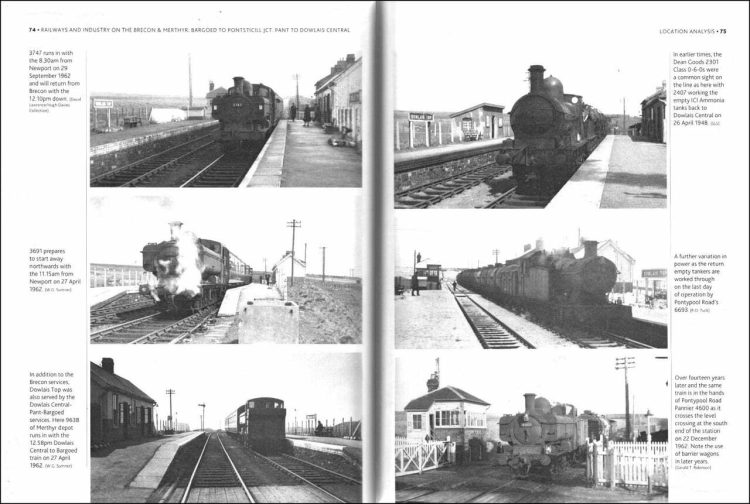
A minor criticism of the book is the seeming lack of good proofreading, such as the caption to the middle-right photo which states that it was taken on the last day of operation, but doesn't make it clear whether it was the line's last day of operation or for the particular type of freight traffic illustrated.
The bottom-right photo then goes on to state that “Over fourteen years later and the same train…”, but although not immediately obvious, it would appear that the text refers to the photo at the top-right.

The majority of the book is taken up by Chapter 2 titled “Location Analysis” which has descriptions and photographs of each station on the line between Bargoed and Pontsticill Junction, and Chapter 3 for the branch from Pant to Dowlais Central.
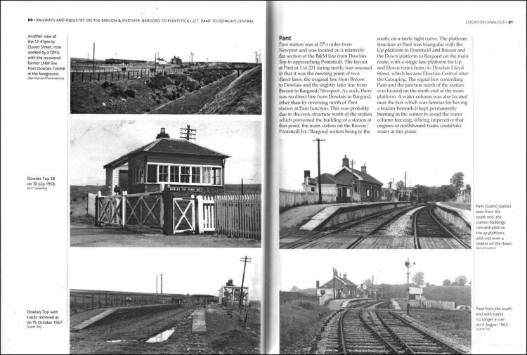
The descriptions of each location, such as the one for Pant seen on the right below, are fairly brief but have sufficient detail to appreciate the layout and complexities of each. As in previous examples, the remoteness of the line can be seen from the photos on the left below.

Another Ordnance Survey map extract is seen on the left below, this one showing the area around Pontsticill Junction, which is the northern limit of the section of the Brecon and Merthyr Railway covered by this book. During the twentieth century, a number of reservoirs were built along the course of the line, such as the one seen in the top-right photo below. It is immediately obvious that at the date of the map opposite the reservoir did not exist.

The photograph at the bottom-left below shows a derelict Ivor Junction signal box, but the authors have omitted to provide any indication in the caption as to where this was located, especially as it is not marked on the Ordnance Survey map accompanying this section of the book, although it is marked on the map at the beginning of the book.
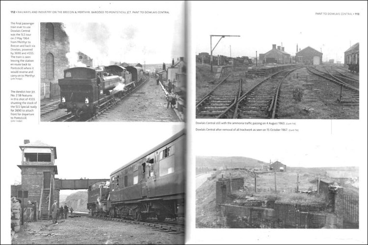
The caption accompanying the photo at the top-right below is rather misleading as it purports to show Dowlais Central still with ammonia traffic passing, yet there is a distinct absence of a freight train.

This book describes every station and halt on this section of the Brecon and Merthyr, accompanied by many photographs of each and some showing scenes after their closure.
Many of the photographs clearly show the isolated locations of some of the stations and halts, which brings out how bleak and desolate they were. There are several instances where the authors have included two, or sometimes three, virtually identical photographs of the same locations.
Although there are a number of photos of early Brecon and Merthyr locomotives, the book lacks full coverage of the motive power deployed on the line, which I assume is to be found in Volume 1.
Some of the photographs lack contrast and would have benefitted from a little editing in a program such as Photoshop before publication. It is clear that the line's major traffic was coal, and there are descriptions of the collieries along the route.
Chapter 3 includes a description of the former large iron works at Dowlais, but there is very little about the nearby ICI ammonia works, even though there are many photographs of the long-distance trains of ammonia tanks serving the works.
The large-scale Ordnance Survey maps are a useful addition, but in at least one instance the topographical features seen in the photographs differ from what is shown on the accompanying maps. The desolate and bleak nature of the line means it would have taken dedicated photographers to record scenes from many locations.
As such, the authors have done well to source the large selection of photographs in the book. However, a cover price of £25 for 120 pages compares badly with Volume 1 which has 248 pages at a cover price of £35.
There is no clue in the publisher's write-up whether a volume describing the section north from Pontsticill Junction to Brecon will follow. A useful work on a neglected railway, with much to interest railway historians and modellers alike and a welcome addition to the volumes on South Wales railways.
The book is available to purchase from Amazon and from Pen & Sword.
We would like to thank Pen & Sword for providing RailAdvent with a copy of the book for review.

